
On a hot summer day, the difference between a shaded sidewalk and one baking in direct sun can be genuinely uncomfortable—especially during a long commute or an outing with kids. Yet no navigation app actually tells you which side of the street has shade, or how to route your walk to avoid the worst heat. I built Shade Compass to solve exactly that problem.
I created this app because I got tired of guessing. During summer commutes across Seoul, I noticed that building shadows and street trees could make one side of the sidewalk 10-15 degrees cooler than the other. Some days, the difference is the only reason a walk feels bearable. I wanted an app that would show me in real time which way to step, not just where to go.
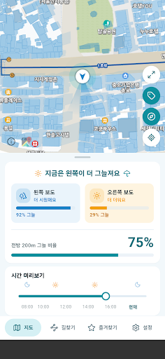
What It Does
- Real-time shade mapping: Calculates shadows from buildings and trees at your current moment, plotted on a map oriented to your walking direction. A time slider lets you preview where shade will shift in the coming hours.
- Left or right: Instead of a compass-north map, you see shading relative to your direction of travel. It simply tells you “the left sidewalk is shaded” so you can act immediately.
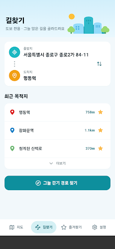
- Shaded route finding: Enter a start point and destination. The app shows you a walking route weighted toward shade, compared side-by-side with the shortest route. You can see the shade percentage for each segment and decide if walking a few minutes longer is worth staying cool.
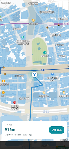
- Walking mode: The screen rotates to face your direction, displays remaining distance, and stays on while you walk. No turn-by-turn voice—it’s designed for pedestrians, not drivers.
- Favorites and time preview: Star frequently visited spots to check shaded routes with one tap. Slide through the day to see how shade patterns shift.
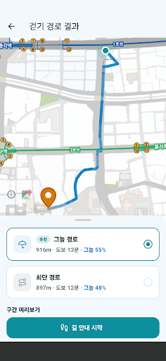
The shadow calculations combine data from 9.6 million buildings and over 1 million street trees across Korea, using the NOAA solar position algorithm. The background map comes from Korea’s Ministry of Land, Infrastructure and Transport. In urban areas nationwide, the app should give you a clear picture of where shade exists right now.
Who This Is For
If you commute 600 meters to the subway and want to stick to the shaded side, this is for you. If you’re walking a child in summer heat and their perceived temperature runs high due to ground radiant heat, this helps. Dog walkers avoiding hot asphalt in the evening, runners choosing the cooler side of a familiar route, or anyone heading out during a heat warning will find real value here. Built specifically for Korea’s urban landscape and climate, where shade availability directly affects summer walkability.
The app is free to use—no sign-up required. Location permissions are used only to calculate shadows at your current spot. Banner ads support the server. Shadow calculations are estimates based on building and tree data, so treat them as guides rather than exact measurements.
If you spend time on foot in Korean cities during summer, download Shade Compass on Google Play and see which side of the street is actually cooler before you step outside.
Play Store에서 다운로드: 그늘나침반 – 그늘길·그늘지도·산책 내비
Official page: reactiveworks.dev/apps/shadecompass
Update history: ahngo13.github.io
Leave a Reply